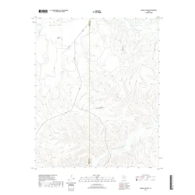
2019 Map of Hughes Canyon
USGS Topo · Published 2019About this map
Antelope Flats dominates the high ground in this section of the Texas Panhandle, where the level terrain of the Llano Estacado begins to drop away into the complex drainage systems of the eastern Caprock. The border between Briscoe and Hall counties runs through a landscape defined by deep erosion, most notably where Palo Duro Canyon and Hughes Canyon carve into the plateau. This 2019 survey documents the vital role of water management in this arid ranching environment, with numerous man-made catchments like Antelope Tank, Harness Tanks, and Wildcat Tanks scattered among the tributary breaks. These water sources support operations away from the larger seasonal flows of the Prairie Dog Town Fork Red River and the Little Red River, which snake through the lower elevations of the canyon floors.
Find a feature on this map
24 named features on this map. Tap any name to fly to it.
Don’t see what you’re looking for? This feature index may not catch every label — zoom into the map to look around manually.
Map Details
Editions of this 2019 Hughes Canyon Map
This is the sole edition of this map. No revisions or reprints were ever made.
Other maps of this area

1954 · Plainview
USGS Topo · 1:250,000

1958 · Plainview
USGS Topo · 1:250,000

1960 · Indian Peak
USGS Topo · 1:62,500

1960 · Brice
USGS Topo · 1:62,500

1967 · Tampico Siding
USGS Topo · 1:24,000

1967 · Turkey
USGS Topo · 1:24,000

1967 · Lake Theo
USGS Topo · 1:24,000

1976 · Brice SE
USGS Topo · 1:24,000

1976 · Brice NW
USGS Topo · 1:24,000
1976 · Indian Peak NE
USGS Topo · 1:24,000