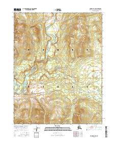
2016 Map of Hughes D-4 SE
USGS Topo · Published 2016About this map
The Kobuk River winds through this northern Alaskan landscape, carving a prominent path through the Lower Kobuk Canyon. This 2016 survey illustrates a transition in land management and preservation, with a significant portion of the eastern territory falling within the Gates of the Arctic National Preserve. The terrain is defined by the hydrologic movement of the river as it bends across the southwestern quadrant, set against the backdrop of the Brooks Range foothills. The absence of roads or established settlements emphasizes the remote, wilderness character of the Northwest Arctic Borough during this era, where the natural watercourse remains the primary geographical landmark for navigation and land identification.
Find a feature on this map
1 named feature on this map. Tap any name to fly to it.
Don’t see what you’re looking for? This feature index may not catch every label — zoom into the map to look around manually.
Map Details
Editions of this 2016 Hughes D-4 SE Map
This is the sole edition of this map. No revisions or reprints were ever made.
Other maps of this area

1951 · Hughes
USGS Topo · 1:250,000

1956 · Hughes
USGS Topo · 1:250,000

1964 · Hughes
USGS Topo · 1:250,000

1965 · Hughes
USGS Topo · 1:250,000
1986 · Hughes C-3
USGS Topo · 1:63,360
1986 · Hughes D-4
USGS Topo · 1:63,360
1986 · Hughes C-4
USGS Topo · 1:63,360
1986 · Hughes D-3
USGS Topo · 1:63,360
2016 · Hughes C-4 NW
USGS Topo · 1:25,000
2016 · Hughes C-4 NE
USGS Topo · 1:25,000