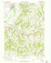
1968 Map of Hughesville
USGS Topo · Published 1972About this map
The borough of Hughesville serves as the primary focal point of this late 1960s survey, situated where Wolf Run meets Muncy Creek in eastern Lycoming County. The landscape is defined by the transition from the relatively flat valley floor, marked by the local Fairgrounds and East Lycoming High Sch, into the steep, deeply dissected ridges to the south and east. Numerous small hollows and runs, such as Miller Hollow Run and Jakes Hollow Run, carve through the uplands of Metler Ridge and Buck Hill, illustrating a rural drainage pattern that directed early settlement and road placement.
Find a feature on this map
60 named features on this map. Tap any name to fly to it.
Don’t see what you’re looking for? This feature index may not catch every label — zoom into the map to look around manually.
Map Details
Editions of this 1968 Hughesville Map
Other maps of this area

1924 · Milton
USGS Topo · 1:62,500

1927 · Eagles Mere
USGS Topo · 1:48,000

1930 · Warrensville
USGS Topo · 1:62,500

1932 · Eagle Mere
USGS Topo · 1:62,500

1934 · Warrensville
USGS Topo · 1:62,500

1935 · Hughesville
USGS Topo · 1:62,500

1953 · Hughesville
USGS Topo · 1:62,500

1953 · Warrensville
USGS Topo · 1:62,500

1953 · Eagles Mere
USGS Topo · 1:62,500

1953 · Milton
USGS Topo · 1:62,500