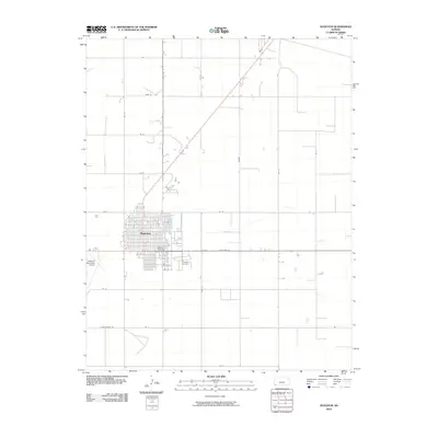
2010 Map of Hugoton
USGS Topo · Published 2010About this map
Hugoton serves as the focal point of this southwestern Kansas landscape, situated at the crossroads of State Hwy 25 and State Hwy 51. The grid of the city is well-defined, showing residential expansion and civic landmarks like the Stevens County Fairgrounds and the Hugoton Cemetery on the eastern edge. Beyond the city limits, the terrain is characterized by a precise rectilinear grid of section roads, including Rd M, Road N, and Rd T, reflecting the region's agricultural heritage and systematic land division. To the west, the Hugoton Municipal Airport stands as a significant piece of transportation infrastructure, while the overall pattern of the map highlights the transition from the concentrated urban center of Hugoton to the expansive, orderly plains typical of Stevens County.
Find a feature on this map
28 named features on this map. Tap any name to fly to it.
Don’t see what you’re looking for? This feature index may not catch every label — zoom into the map to look around manually.
Map Details
Editions of this 2010 Hugoton Map
This is the sole edition of this map. No revisions or reprints were ever made.
Other maps of this area

1944 · Moscow
USGS Topo · 1:62,500

1945 · Moscow
USGS Topo · 1:62,500

1955 · Dodge City
USGS Topo · 1:250,000

1958 · Dodge City
USGS Topo · 1:250,000

1959 · Dodge City
USGS Topo · 1:250,000
1974 · Hugoton SE
USGS Topo · 1:24,000

1974 · Hugoton
USGS Topo · 1:24,000

1974 · Feterita
USGS Topo · 1:24,000
1974 · Hugoton SW
USGS Topo · 1:24,000
1974 · Wagon Bed Spring SW
USGS Topo · 1:24,000