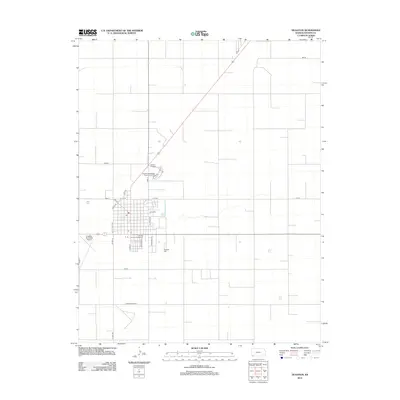
2012 Map of Hugoton
USGS Topo · Published 2012About this map
The grid of S Main St and S Adams St defines the residential and commercial heart of Hugoton in this 2012 topographic record. The landscape shows a town structured by utility and municipal planning, from the centrally located Po to the peripheral Hugoton Municipal Airport and Hugoton Wastewater Treatment Facility. The community's social and recreational focal points are clear, with the Stevens County Fairgrounds south of the main thoroughfares and the Dirtona Raceway positioned to the north. Surrounding the town, the geometric precision of county roads like 1 Mi Rd and 5 Mi Rd reflects the organized agricultural heritage of the High Plains. This survey provides a clear view of the town's modern footprint, including the expansive Hugoton Cem southeast of the city center.
Find a feature on this map
26 named features on this map. Tap any name to fly to it.
Don’t see what you’re looking for? This feature index may not catch every label — zoom into the map to look around manually.
Map Details
Editions of this 2012 Hugoton Map
This is the sole edition of this map. No revisions or reprints were ever made.
Other maps of this area

1944 · Moscow
USGS Topo · 1:62,500

1945 · Moscow
USGS Topo · 1:62,500

1955 · Dodge City
USGS Topo · 1:250,000

1958 · Dodge City
USGS Topo · 1:250,000

1959 · Dodge City
USGS Topo · 1:250,000
1974 · Hugoton SE
USGS Topo · 1:24,000

1974 · Hugoton
USGS Topo · 1:24,000

1974 · Feterita
USGS Topo · 1:24,000
1974 · Hugoton SW
USGS Topo · 1:24,000
1974 · Wagon Bed Spring SW
USGS Topo · 1:24,000