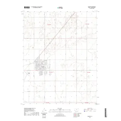
2018 Map of Hugoton
USGS Topo · Published 2018About this map
Hugoton serves as the focal point of this southwestern Kansas landscape, centered within Stevens County. The grid-patterned town site is characterized by an extensive network of residential and commercial streets, including E 1st St and W 11th St, which reflect the community's organized expansion. Just south of the main residential area lies the Hugoton Cem, a significant site for local genealogical research. To the west, the Hugoton Municipal Airport indicates the region's connection to aerial commerce and transport. The surrounding territory is divided into large sections by a functional network of rural roads such as Road N and Rd S, illustrating the agricultural character of the high plains. This 2018 survey captures the interface between the urban core and the wide-open township ranges typical of the Kansas panhandle region.
Find a feature on this map
42 named features on this map. Tap any name to fly to it.
Don’t see what you’re looking for? This feature index may not catch every label — zoom into the map to look around manually.
Map Details
Editions of this 2018 Hugoton Map
This is the sole edition of this map. No revisions or reprints were ever made.
Other maps of this area

1944 · Moscow
USGS Topo · 1:62,500

1945 · Moscow
USGS Topo · 1:62,500

1955 · Dodge City
USGS Topo · 1:250,000

1958 · Dodge City
USGS Topo · 1:250,000

1959 · Dodge City
USGS Topo · 1:250,000
1974 · Hugoton SE
USGS Topo · 1:24,000

1974 · Hugoton
USGS Topo · 1:24,000

1974 · Feterita
USGS Topo · 1:24,000
1974 · Hugoton SW
USGS Topo · 1:24,000
1974 · Wagon Bed Spring SW
USGS Topo · 1:24,000