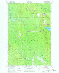
1951 Map of Hulbert
USGS Topo · Published 1977About this map
The Hulbert settlement and the surrounding Tahquamenon River State Forest define this 1950s landscape in the Upper Peninsula. Situated on the Duluth South Shore and Atlantic railroad, the community serves as a hub for the region's timber and recreational economy. The map illustrates a dense network of watercourses, including the Tahquamenon River and the meandering Hendrie River, which join several branches to drain the low-lying terrain.
Find a feature on this map
16 named features on this map. Tap any name to fly to it.
Don’t see what you’re looking for? This feature index may not catch every label — zoom into the map to look around manually.
Map Details
Editions of this 1951 Hulbert Map
Other maps of this area

1931 · Epoufette NE
USGS Topo · 1:31,680

1931 · Epoufette NW
USGS Topo · 1:31,680

1931 · Gilchrist NE
USGS Topo · 1:31,680

1951 · Piatt Lake
USGS Topo · 1:24,000

1951 · Big Beaver Creek
USGS Topo · 1:24,000

1951 · Hulbert
USGS Topo · 1:24,000

1951 · Eckerman
USGS Topo · 1:24,000

1951 · Eckerman
USGS Topo · 1:62,500

1954 · Sault Sainte Marie
USGS Topo · 1:250,000

1956 · Sault Sainte Marie
USGS Topo · 1:250,000