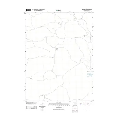
2011 Map of Hulbert Lake
USGS Topo · Published 2011About this map
Large cattle operations and remote sandhills homesteads define this section of Arthur County, Nebraska. The landscape is marked by a network of ranch properties, including the Peterson Ranch, Spencer Ranch, and the expansive Hawkins Ranch, which is served by its own private airstrip, the Hawkins Ranch Airport. These family-named landmarks reflect a long-standing agricultural tradition where roads are often named for the residents they serve, such as Kaps Rd and Sillassen Rd. In the southeastern corner, the geography shifts toward Haythorn Valley, where Haythorn Lake provides a rare water source for the surrounding Haythorn Ranch. The map reveals the isolation of these Sandhills outposts, connected by thoroughfares like Valentine Rd that stretch across the open plains between distant neighbors such as Schneede Ranch and Frye Ranch.
Find a feature on this map
23 named features on this map. Tap any name to fly to it.
Don’t see what you’re looking for? This feature index may not catch every label — zoom into the map to look around manually.
Map Details
Editions of this 2011 Hulbert Lake Map
This is the sole edition of this map. No revisions or reprints were ever made.
Other maps of this area

1897 · Ogallala
USGS Topo · 1:125,000

1900 · Ogallala
USGS Topo · 1:125,000

1949 · Arthur
USGS Topo · 1:62,500

1950 · Velma
USGS Topo · 1:62,500

1950 · Arthur
USGS Topo · 1:62,500

1954 · North Platte
USGS Topo · 1:250,000

1956 · North Platte
USGS Topo · 1:250,000

1957 · North Platte
USGS Topo · 1:250,000

1967 · North Platte
USGS Topo · 1:250,000
1971 · Bear Hill
USGS Topo · 1:24,000