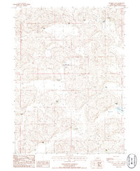
1986 Map of Hulbert Lake
USGS Topo · Published 1986About this map
The cattle-ranching heritage of the Sandhills is clearly etched across this 1980s landscape in Arthur County. The map reveals a high density of named family operations, including the Hartman Ranch, Kaps Ranch, and Frye Ranch in the north, and the Schneede Ranch and Wilson Ranch to the south. This concentration of named holdings like Rasmussen Place and Porter Place provides a detailed look at the rural land-tenure patterns of central Nebraska during this era. The terrain is defined by the depressions of Hulbert Lake and Haythorn Lake, with the latter situated at the head of Haythorn Valley. A remote Landing Strip near the Hawkins Ranch underscores the vast distances and logistical needs of these isolated ranching outposts.
Find a feature on this map
20 named features on this map. Tap any name to fly to it.
Don’t see what you’re looking for? This feature index may not catch every label — zoom into the map to look around manually.
Map Details
Editions of this 1986 Hulbert Lake Map
This is the sole edition of this map. No revisions or reprints were ever made.
Other maps of this area

1897 · Ogallala
USGS Topo · 1:125,000

1900 · Ogallala
USGS Topo · 1:125,000

1949 · Arthur
USGS Topo · 1:62,500

1950 · Velma
USGS Topo · 1:62,500

1950 · Arthur
USGS Topo · 1:62,500

1954 · North Platte
USGS Topo · 1:250,000

1956 · North Platte
USGS Topo · 1:250,000

1957 · North Platte
USGS Topo · 1:250,000

1967 · North Platte
USGS Topo · 1:250,000
1971 · Bear Hill
USGS Topo · 1:24,000