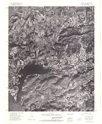
1972 Map of Hulbert NW
USGS Topo · Published 1974About this map
Fort Gibson Lake dominates the southwestern portion of this 1970s orthophotoquad, showing the intricate shoreline and surrounding wooded terrain of Cherokee County. The imagery, captured by the Usgs from 1972 aerial photography, provides a literal visual record of the landscape at a time when the community of Hulbert was established as a local hub. Moving east from the lake, the drainage patterns of Fourteenmile Creek and Double Spring Creek carve through the topography, revealing the land-use patterns between the water and the settlement. This orthophoto format allows researchers to see the actual vegetation and road signatures that traditional line-drawn maps often abstract, making it a valuable tool for understanding the mid-century development of this Oklahoma region.
Find a feature on this map
4 named features on this map. Tap any name to fly to it.
Don’t see what you’re looking for? This feature index may not catch every label — zoom into the map to look around manually.
Map Details
Editions of this 1972 Hulbert NW Map
This is the sole edition of this map. No revisions or reprints were ever made.
Other maps of this area

1896 · Pryor
USGS Topo · 1:125,000

1901 · Muscogee
USGS Topo · 1:125,000

1901 · Pryor
USGS Topo · 1:125,000

1905 · Muscogee
USGS Topo · 1:125,000

1946 · Fort Smith
USGS Topo · 1:250,000

1948 · Hulbert
USGS Topo · 1:62,500

1948 · Wagoner
USGS Topo · 1:62,500

1950 · Wagoner
USGS Topo · 1:62,500

1950 · Hulbert
USGS Topo · 1:62,500

1954 · Tulsa
USGS Topo · 1:250,000