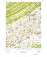
1956 Map of Hummelstown
USGS Topo · Published 1976About this map
Hershey and the Milton Hershey School occupy a central role in this mid-century landscape, illustrating the significant industrial and educational footprint of the chocolate company. The map reveals a structured townsite complete with a Stadium, Hershey Country Club, and its own Hershey Air Park. Beyond the company town, the landscape transitions into the specialized training grounds of the US Military Reservation Indiantown Gap, where a complex network of barracks and service buildings is nestled against the southern face of Blue Mountain.
Find a feature on this map
120 named features on this map. Tap any name to fly to it.
Don’t see what you’re looking for? This feature index may not catch every label — zoom into the map to look around manually.
Map Details
Editions of this 1956 Hummelstown Map
Other maps of this area

1891 · Lebanon
USGS Topo · 1:62,500

1892 · Lykens
USGS Topo · 1:62,500

1892 · Hummelstown
USGS Topo · 1:62,500

1892 · Harrisburg
USGS Topo · 1:62,500

1892 · Pine Grove
USGS Topo · 1:62,500

1893 · Lykens
USGS Topo · 1:62,500

1893 · Lebanon
USGS Topo · 1:62,500

1893 · Millersburg
USGS Topo · 1:62,500

1899 · Lebanon
USGS Topo · 1:62,500

1899 · Harrisburg
USGS Topo · 1:62,500
Featured Places
- Hershey, Derry Township
- Palmyra, PA
- Campbelltown, South Londonderry Township
- Rutherford, Swatara Township
- Annville, PA