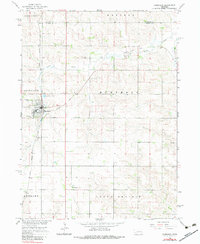
1966 Map of Humphrey
USGS Topo · Published 1983About this map
Humphrey serves as the central hub of this Nebraska landscape, situated at the junction of the Union Pacific and an Old Grade Railroad. The town's religious and civic character is defined by landmarks like St Francis Cem and its proximity to the industrial Claypit on the southern edge of the settlement. The surrounding territory is divided into distinctive townships such as Granville, Burrows, and Grand Prairie, reflecting the organized agricultural development of Platte and Madison Counties.
Find a feature on this map
21 named features on this map. Tap any name to fly to it.
Don’t see what you’re looking for? This feature index may not catch every label — zoom into the map to look around manually.
Map Details
Editions of this 1966 Humphrey Map
2 editions found
Other maps of this area

1955 · Fremont
USGS Topo · 1:250,000

1957 · Fremont
USGS Topo · 1:250,000

1958 · Fremont
USGS Topo · 1:250,000

1963 · Madison
USGS Topo · 1:24,000

1963 · Madison SE
USGS Topo · 1:24,000

1963 · Battle Creek SE
USGS Topo · 1:24,000

1966 · Tarnov
USGS Topo · 1:24,000

1966 · Platte Center
USGS Topo · 1:24,000

1966 · Humphrey SE
USGS Topo · 1:24,000

1966 · Creston
USGS Topo · 1:24,000