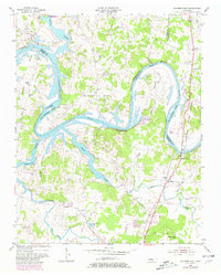
1955 Map of Hunters Point
USGS Topo · Published 1981About this map
The Cumberland River defines this region of Middle Tennessee, winding through sharp oxbows like Belotes Bend and Canoe Bend. By the mid-1950s, the formation of Old Hickory Lake significantly altered the shoreline, creating new recreation opportunities at Bledsoe Creek Camping State Park. Despite these changes, the rural character remains centered around historic crossroads and river landings. Settlements such as Cairo, Hunters Point, and Macedonia serve as local anchors, while the Nathan J Harsh Bridge provides a vital crossing near the confluence of Spring Creek.
Find a feature on this map
48 named features on this map. Tap any name to fly to it.
Don’t see what you’re looking for? This feature index may not catch every label — zoom into the map to look around manually.
Map Details
Editions of this 1955 Hunters Point Map
4 editions found
Other maps of this area

1942 · Statesville
USGS Topo · 1:100,000

1942 · Gallatin
USGS Topo · 1:100,000

1942 · Lebanon
USGS Topo · 1:100,000

1951 · Lebanon
USGS Topo · 1:24,000

1951 · Martha
USGS Topo · 1:24,000

1955 · Bethpage
USGS Topo · 1:24,000

1955 · Laguardo
USGS Topo · 1:24,000

1955 · Hunters Point
USGS Topo · 1:24,000

1955 · Gallatin
USGS Topo · 1:24,000

1956 · Nashville
USGS Topo · 1:250,000