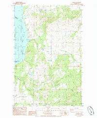
1985 Map of Hunters
USGS Topo · Published 1985About this map
The community of Hunters and the nearby settlement of Fruitland anchor this mid-1980s landscape along the eastern shores of Franklin D Roosevelt Lake. This stretch of the Columbia River is part of the Coulee Dam National Recreation Area, where the rising waters of the mid-century have transformed the river valley. The map documents the interface between private land and the northern reaches of the Spokane Indian Reservation, which occupies the southern portion of the sheet. Inland from the river, the terrain is defined by rugged drainages like Coyote Canyon and O-Ra-Pak-En Creek, punctuated by industrial landmarks such as the H and B Mine and several Borrow Pits. Local genealogists will find several Cem markings and small water bodies like Mudgett Lake and Newbill Lake that characterize this rural Stevens County corridor.
Find a feature on this map
21 named features on this map. Tap any name to fly to it.
Don’t see what you’re looking for? This feature index may not catch every label — zoom into the map to look around manually.
Map Details
Editions of this 1985 Hunters Map
2 editions found
Other maps of this area

1948 · Hunters
USGS Topo · 1:62,500

1948 · Wilmont Creek
USGS Topo · 1:62,500

1948 · Lincoln
USGS Topo · 1:62,500

1948 · Turtle Lake
USGS Topo · 1:62,500

1950 · Lincoln
USGS Topo · 1:62,500

1950 · Turtle Lake
USGS Topo · 1:62,500

1950 · Wilmont Creek
USGS Topo · 1:62,500

1950 · Hunters
USGS Topo · 1:62,500

1953 · Ritzville
USGS Topo · 1:250,000

1954 · Okanogan
USGS Topo · 1:250,000