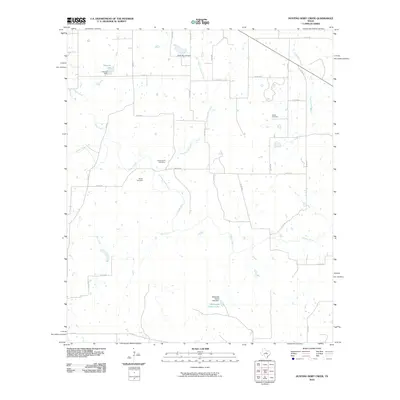
2010 Map of Hunting Shirt Creek
USGS Topo · Published 2010About this map
Hunting Shirt Creek and the Sabana River converge in this section of Eastland County, defining a landscape of riparian corridors and small-scale water management. The terrain is dotted with several significant local landmarks for genealogical research, including Jewel Cemetery in the northeast and Brown Cemetery further south. The presence of features such as Hammer Lake and Whiteside Estate Lake, each supported by dams like the Hamner Dam and Whiteside Estate Lake Dam, illustrates a rural Texas environment focused on water impoundment. The county road network, including Main St and Co Rd 408, provides a grid that connects these water sources and burial grounds. This map offers a clear look at the hydrologic patterns of Elm Creek and Currycomb Branch as they wind through the ranching and agricultural lands characteristic of the region.
Find a feature on this map
35 named features on this map. Tap any name to fly to it.
Don’t see what you’re looking for? This feature index may not catch every label — zoom into the map to look around manually.
Map Details
Editions of this 2010 Hunting Shirt Creek Map
This is the sole edition of this map. No revisions or reprints were ever made.
Other maps of this area

1894 · Eastland
USGS Topo · 1:125,000

1954 · Abilene
USGS Topo · 1:250,000

1958 · Abilene
USGS Topo · 1:250,000

1966 · Sipe Springs
USGS Topo · 1:24,000
1966 · Rising Star
USGS Topo · 1:24,000

1966 · Kokomo
USGS Topo · 1:24,000

1966 · Carbon
USGS Topo · 1:24,000

1966 · Cisco South
USGS Topo · 1:24,000
1968 · Gorman
USGS Topo · 1:24,000
1969 · Duster
USGS Topo · 1:24,000