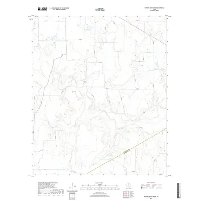
2019 Map of Hunting Shirt Creek
USGS Topo · Published 2019About this map
The Sabana River and its numerous tributaries, including Hunting Shirt Cr and Elm Cr, carve a complex drainage pattern across this rural borderland between Eastland and Comanche counties. The landscape is defined by its watercourses and small ranching impoundments like Hammer Lake and Whiteside Estate Lake, connected by an extensive network of county roads. For genealogists and local historians, the map serves as a vital record of early community hubs, preserving the locations of three distinct burial grounds: Jewel Cem, Center Point Cem, and Brown Cem. These sites, often the only remaining markers of vanished rural settlements, are situated along ridges and creek bends. The winding path of Main St in the northwest and the branching of Currycomb Br in the northeast illustrate the enduring rural character of this Central Texas region during the late 2010s.
Find a feature on this map
38 named features on this map. Tap any name to fly to it.
Don’t see what you’re looking for? This feature index may not catch every label — zoom into the map to look around manually.
Map Details
Editions of this 2019 Hunting Shirt Creek Map
This is the sole edition of this map. No revisions or reprints were ever made.
Other maps of this area

1894 · Eastland
USGS Topo · 1:125,000

1954 · Abilene
USGS Topo · 1:250,000

1958 · Abilene
USGS Topo · 1:250,000

1966 · Sipe Springs
USGS Topo · 1:24,000
1966 · Rising Star
USGS Topo · 1:24,000

1966 · Kokomo
USGS Topo · 1:24,000

1966 · Carbon
USGS Topo · 1:24,000

1966 · Cisco South
USGS Topo · 1:24,000
1968 · Gorman
USGS Topo · 1:24,000
1969 · Duster
USGS Topo · 1:24,000