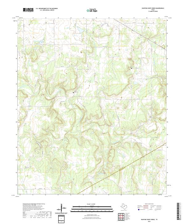
2022 Map of Hunting Shirt Creek
USGS Topo · Published 2022About this map
Center Point Cem and Brown Cem sit within the winding loops of the Sabana River and its tributary, Hunting Shirt Creek, illustrating a landscape defined by its waterways and rural burial grounds. The river snakes across the central terrain, joined by smaller flows such as Elm Cr and Greer Cr, while Whiteside Estate Lake and Hammer Lake mark the local hydrology. This 2022 survey captures the borderlands of the Eastland and Comanche County line, where the land is partitioned by a grid of county roads. For genealogists and local historians, the inclusion of Jewell Cem and other family or community cemeteries provides specific points of reference for tracing early North Texas heritage in a region where these landmarks remain the primary anchors of local history.
Find a feature on this map
38 named features on this map. Tap any name to fly to it.
Don’t see what you’re looking for? This feature index may not catch every label — zoom into the map to look around manually.
Map Details
Editions of this 2022 Hunting Shirt Creek Map
This is the sole edition of this map. No revisions or reprints were ever made.
Other maps of this area

1894 · Eastland
USGS Topo · 1:125,000

1954 · Abilene
USGS Topo · 1:250,000

1958 · Abilene
USGS Topo · 1:250,000

1966 · Sipe Springs
USGS Topo · 1:24,000
1966 · Rising Star
USGS Topo · 1:24,000

1966 · Kokomo
USGS Topo · 1:24,000

1966 · Carbon
USGS Topo · 1:24,000

1966 · Cisco South
USGS Topo · 1:24,000
1968 · Gorman
USGS Topo · 1:24,000
1969 · Duster
USGS Topo · 1:24,000