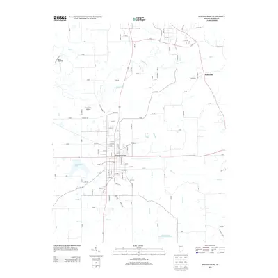
2013 Map of Huntingburg
USGS Topo · Published 2013About this map
Huntingburg serves as the central hub of this Dubois County landscape, where the local street grid intersects with the Indiana Western RR. The town is surrounded by a network of watercourses and low-lying areas, including the wide Patoka River and the descriptively named Duck Pond Bottom. To the northwest, the terrain takes on a sharper character at Devils Backbone, while several reservoirs like Huntingburg Lake and the Huntingburg Conservation Club Lake suggest a history of local water management and recreation. To the east, the smaller settlement of Maltersville sits near the headwaters of Flat Cr, illustrating the dispersed nature of rural Dubois County in the early twenty-first century. The map provides a detailed view of the rural-to-urban transition, where long-established county roads like Co Rd-250 meet the expanding residential outskirts of the city.
Find a feature on this map
141 named features on this map. Tap any name to fly to it.
Don’t see what you’re looking for? This feature index may not catch every label — zoom into the map to look around manually.
Map Details
Editions of this 2013 Huntingburg Map
This is the sole edition of this map. No revisions or reprints were ever made.
Other maps of this area

1900 · St Meinrad
USGS Topo · 1:62,500

1900 · De Gonia Springs
USGS Topo · 1:62,500

1902 · Ditney
USGS Topo · 1:125,000

1902 · Degonia Springs
USGS Topo · 1:62,500

1903 · St. Meinrad
USGS Topo · 1:62,500

1903 · Velpen
USGS Topo · 1:62,500

1946 · Jasper
USGS Topo · 1:24,000

1954 · Dubois
USGS Topo · 1:24,000

1954 · Huntingburg
USGS Topo · 1:24,000

1955 · Saint Anthony
USGS Topo · 1:24,000