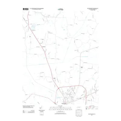
2013 Map of Huntingdon
USGS Topo · Published 2013About this map
The town of Huntingdon serves as the central hub in this Carroll County landscape, where the local economy and geography are shaped by a complex network of waterways and infrastructure. North of the town center, Carroll Lake and the Carroll Lake Dam regulate the flow of Clear Cr, while the Carroll County Airport provides an aerial gateway just outside Fairview. The map reveals a pattern of small settlements and rural crossroads like Bethel, Hico, and Long Rock, all connected by a web of local routes such as Langford Store Rd and Fairview Church Rd. A notable engineering feature is the Crooked Creek Drainage Canal, which cuts across the central portion of the quadrangle to manage the low-lying terrain near Beaver Creek. From the residential streets of the county seat to the quiet waters of Lake Isabel, the map documents a community deeply integrated with its creek-fed bottomlands and agricultural backroads.
Find a feature on this map
124 named features on this map. Tap any name to fly to it.
Don’t see what you’re looking for? This feature index may not catch every label — zoom into the map to look around manually.
Map Details
Editions of this 2013 Huntingdon Map
This is the sole edition of this map. No revisions or reprints were ever made.
Other maps of this area

1936 · Mansfield
USGS Topo · 1:24,000

1936 · Vale
USGS Topo · 1:24,000

1936 · Center Ridge
USGS Topo · 1:24,000

1936 · Buena Vista
USGS Topo · 1:24,000

1950 · Palmer Shelter
USGS Topo · 1:24,000

1950 · Vale
USGS Topo · 1:24,000
1950 · Buena Vista
USGS Topo · 1:24,000

1950 · Mansfield
USGS Topo · 1:24,000

1955 · Henry
USGS Topo · 1:24,000

1955 · Huntingdon
USGS Topo · 1:24,000