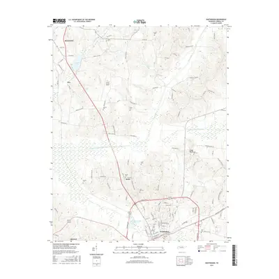
2016 Map of Huntingdon
USGS Topo · Published 2016About this map
Huntingdon serves as the focal point of this Carroll County survey, situated at the intersection of local routes and natural waterways. The landscape is defined by the managed flow of the Crooked Cr Drainage Canal, which cuts through the low-lying wetlands between Hico and the southern settlements. This drainage network, including the Crooked Creek Drainage Canal, illustrates the mid-century engineering efforts to control the local hydrology for agricultural and municipal stability. To the north, Carroll Lake and Lake Isabel provide significant water features near the Carroll County Airport. The distribution of family and community burial grounds, such as Shiloh Cem, McAdoo Cem, and Finley Cem, reveals a long-standing pattern of rural settlement. These sites, along with smaller nodes like Bethel and Lakewood, highlight the genealogical history and established residential footprint of the region.
Find a feature on this map
102 named features on this map. Tap any name to fly to it.
Don’t see what you’re looking for? This feature index may not catch every label — zoom into the map to look around manually.
Map Details
Editions of this 2016 Huntingdon Map
This is the sole edition of this map. No revisions or reprints were ever made.
Other maps of this area

1936 · Mansfield
USGS Topo · 1:24,000

1936 · Vale
USGS Topo · 1:24,000

1936 · Center Ridge
USGS Topo · 1:24,000

1936 · Buena Vista
USGS Topo · 1:24,000

1950 · Palmer Shelter
USGS Topo · 1:24,000

1950 · Vale
USGS Topo · 1:24,000
1950 · Buena Vista
USGS Topo · 1:24,000

1950 · Mansfield
USGS Topo · 1:24,000

1955 · Henry
USGS Topo · 1:24,000

1955 · Huntingdon
USGS Topo · 1:24,000