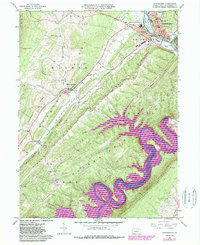
1963 Map of Huntingdon
USGS Topo · Published 1989About this map
The Juniata River and its dramatic winding Raystown Branch carve through a landscape of parallel ridges including Warrior Ridge and Allegrippis Ridge. The county seat of Huntingdon serves as the regional hub, home to Juniata College and the State Correctional Institution. This 1963 survey, updated with 1981 photorevisions, captures the area during the expansion of the Raystown Lake Recreation Area, showing the inundation of the river valley behind the Raystown Dam.
Find a feature on this map
55 named features on this map. Tap any name to fly to it.
Don’t see what you’re looking for? This feature index may not catch every label — zoom into the map to look around manually.
Map Details
Editions of this 1963 Huntingdon Map
4 editions found
Other maps of this area

1901 · Huntingdon
USGS Topo · 1:62,500

1904 · Huntingdon
USGS Topo · 1:62,500

1919 · Menno
USGS Topo · 1:62,500

1922 · Mt Union
USGS Topo · 1:48,000

1923 · Tyrone
USGS Topo · 1:62,500

1924 · Mt. Union
USGS Topo · 1:62,500

1929 · Tyrone
USGS Topo · 1:48,000

1933 · Tyrone
USGS Topo · 1:62,500

1935 · Allensville
USGS Topo · 1:62,500

1938 · Allensville
USGS Topo · 1:62,500