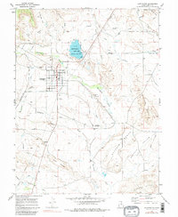
1969 Map of Huntington
USGS Topo · Published 1980About this map
The town of Huntington serves as the central hub for this late-1960s landscape, illustrating a complex network of water management through features like the North Ditch, Cleveland Center Ditch, and a series of unnamed canals and aqueducts. The area is defined by its distinct bench formations, including the prominent Buffalo Bench and Level Bench, which rise above the surrounding washes and flats. To the north, the Huntington Lake State Beach provides a localized water body adjacent to a large substation, reflecting the infrastructure required to support this desert community.
Find a feature on this map
45 named features on this map. Tap any name to fly to it.
Don’t see what you’re looking for? This feature index may not catch every label — zoom into the map to look around manually.
Map Details
Editions of this 1969 Huntington Map
3 editions found
Other maps of this area

1885 · Manti
USGS Topo · 1:250,000

1886 · Price River
USGS Topo · 1:250,000

1895 · Manti
USGS Topo · 1:250,000

1896 · Price River
USGS Topo · 1:250,000

1923 · Castle Dale
USGS Topo · 1:62,500

1923 · Hiawatha
USGS Topo · 1:62,500

1925 · Castle Dale
USGS Topo · 1:62,500

1925 · Hiawatha
USGS Topo · 1:62,500

1956 · Price
USGS Topo · 1:250,000

1960 · Price
USGS Topo · 1:250,000