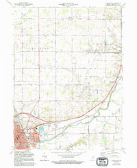
1972 Map of Huntington
USGS Topo · Published 1994About this map
Huntington serves as the focal point of this Indiana landscape, where the confluence of the Little River and local tributaries like Clear Creek and Flat Creek shaped early development. The city's mid-century footprint includes Huntington College and several educational institutions such as Horace Mann Sch and Riley Sch. A significant historical landmark, the Old Indian Treaty Boundary, cuts diagonally across the northeastern territory, a relic of early 19th-century land divisions that still influenced the rural grid of 1100 North Road and surrounding acreage in the early 1970s.
Find a feature on this map
62 named features on this map. Tap any name to fly to it.
Don’t see what you’re looking for? This feature index may not catch every label — zoom into the map to look around manually.
Map Details
Editions of this 1972 Huntington Map
Other maps of this area

1950 · Andrews
USGS Topo · 1:24,000

1951 · Andrews
USGS Topo · 1:24,000

1952 · Majenica
USGS Topo · 1:24,000

1953 · Fort Wayne
USGS Topo · 1:250,000

1953 · Muncie
USGS Topo · 1:250,000

1955 · Markle
USGS Topo · 1:24,000

1955 · Bippus
USGS Topo · 1:24,000

1956 · Muncie
USGS Topo · 1:250,000

1956 · Fort Wayne
USGS Topo · 1:250,000

1956 · Huntington
USGS Topo · 1:24,000