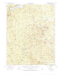
1953 Map of Huntington Lake
USGS Topo · Published 1968About this map
Huntington Lake and the high Sierra backcountry of Fresno County are shown here as they appeared in the early 1950s. The landscape is defined by a dense network of mountain trails and glacial lakes, including First Dinkey Lake, Island Lake, and Swamp Lake. This era highlights the area's mid-century role as a center for both recreation and timber, evidenced by several specialized settlements like the Pine Logging Camp, Byles Jamison Camp, and Bretz Mill.
Find a feature on this map
124 named features on this map. Tap any name to fly to it.
Don’t see what you’re looking for? This feature index may not catch every label — zoom into the map to look around manually.
Map Details
Editions of this 1953 Huntington Lake Map
4 editions found

Other maps of this area

1903 · Tehipite
USGS Topo · 1:125,000

1904 · Kaiser
USGS Topo · 1:125,000

1905 · Tehipite
USGS Topo · 1:125,000

1912 · Mt. Goddard
USGS Topo · 1:125,000

1922 · Trimmer
USGS Topo · 1:96,000

1924 · Dinuba
USGS Topo · 1:125,000

1942 · Watts Valley
USGS Topo · 1:62,500

1944 · Watts Valley
USGS Topo · 1:62,500

1947 · Mariposa
USGS Topo · 1:250,000

1948 · Fresno
USGS Topo · 1:250,000