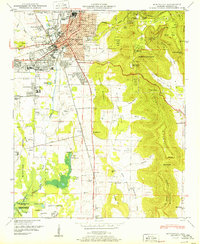
1950 Map of Huntsville
USGS Topo · Published 1950About this map
Huntsville sits at the base of the dramatic Cumberland Plateau, dominated here by the steep slopes of Monte Sano Mountain and Huntsville Mountain. In this mid-century period, the city is bounded to the west by the expanding military presence of the Redstone Arsenal and Huntsville Arsenal, marking the region's transition into a center for aerospace and defense. Within the city grid, established neighborhoods like Terry Heights, West Huntsville, and Madison Heights surround the central business district.
Find a feature on this map
101 named features on this map. Tap any name to fly to it.
Don’t see what you’re looking for? This feature index may not catch every label — zoom into the map to look around manually.
Map Details
Editions of this 1950 Huntsville Map
2 editions found
Other maps of this area

1888 · Scottsboro
USGS Topo · 1:125,000

1888 · Huntsville
USGS Topo · 1:125,000

1892 · Huntsville
USGS Topo · 1:125,000

1892 · Scottsboro
USGS Topo · 1:125,000

1936 · Jeff
USGS Topo · 1:24,000

1936 · Triana
USGS Topo · 1:24,000

1936 · New Hope
USGS Topo · 1:24,000

1936 · Madison
USGS Topo · 1:24,000

1936 · Meridianville
USGS Topo · 1:24,000

1936 · Moontown
USGS Topo · 1:24,000