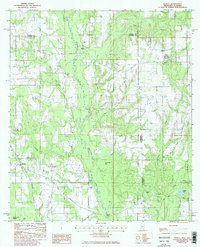
1982 Map of Hurley
USGS Topo · Published 1986About this map
The Es Catawpa River snakes through the heart of the Mississippi-Alabama borderlands, carving a wide valley defined by distinctive high points like Yellow Bluff, Red Bluff, and White Bluff. In this corner of Jackson County, the settlement of Hurley serves as a local hub near the southern reaches of Black Creek Swamp, while the small community of Arena sits further south. The landscape is a network of small family-named landmarks and rural institutions, including Tanners Chapel and Tanners Cem in the north and Roberts Chapel to the east.
Find a feature on this map
35 named features on this map. Tap any name to fly to it.
Don’t see what you’re looking for? This feature index may not catch every label — zoom into the map to look around manually.
Map Details
Editions of this 1982 Hurley Map
2 editions found
Other maps of this area

1941 · Hurley
USGS Topo · 1:62,500

1941 · Vancleave
USGS Topo · 1:62,500

1941 · Lucedale
USGS Topo · 1:62,500

1942 · Wilmer
USGS Topo · 1:62,500

1943 · Lucedale
USGS Topo · 1:62,500

1943 · Hurley
USGS Topo · 1:62,500

1943 · Vancleave
USGS Topo · 1:62,500

1944 · Wilmer
USGS Topo · 1:62,500

1944 · Vancleave
USGS Topo · 1:62,500

1953 · Mobile
USGS Topo · 1:250,000