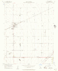
1956 Map of Huron
USGS Topo · Published 1957About this map
The agricultural landscape of Huron is defined by a rigid grid of avenues named for prominent California peaks and counties, such as Lassen Avenue and Madera Avenue. In the mid-1950s, this area of Fresno County was a center of intensive large-scale farming and industrial processing, evidenced by the numerous labor camps and grain tanks scattered across the map. The Southern Pacific railroad serves as the primary artery for the town, flanked by infrastructure like the Cotton Gin and a Fire Control Station.
Find a feature on this map
43 named features on this map. Tap any name to fly to it.
Don’t see what you’re looking for? This feature index may not catch every label — zoom into the map to look around manually.
Map Details
Editions of this 1956 Huron Map
4 editions found
Other maps of this area

1912 · Coalinga
USGS Topo · 1:125,000

1926 · Lethent
USGS Topo · 1:31,680

1928 · Delta Farms No 3
USGS Topo · 1:31,680

1929 · Westhaven
USGS Topo · 1:31,680

1930 · Discovery Well
USGS Topo · 1:31,680

1930 · Canoas Creek
USGS Topo · 1:31,680

1932 · Delta Farms
USGS Topo · 1:31,680

1932 · West of Lethent
USGS Topo · 1:31,680

1933 · Kettleman City
USGS Topo · 1:31,680

1933 · Huron
USGS Topo · 1:31,680