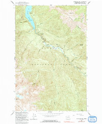
1950 Map of Hurricane Hill
USGS Topo · Published 1991About this map
Lake Mills dominates the northern landscape of this Olympic Peninsula survey, where the Elwha River carves through deep geological formations. The river’s path is marked by dramatic terrain features including Goblins Gate and the steep walls of Rica Canyon. Small outposts of human activity appear at Michaels Ranch and Humes Ranch within the Geyser Valley, while the higher elevations of the Bailey Range are defined by the Fairchild Glacier and Mt Fitzhenry.
Find a feature on this map
40 named features on this map. Tap any name to fly to it.
Don’t see what you’re looking for? This feature index may not catch every label — zoom into the map to look around manually.
Map Details
Editions of this 1950 Hurricane Hill Map
5 editions found
Other maps of this area

1918 · Port Angeles
USGS Topo · 1:62,500

1919 · Port Crescent
USGS Topo · 1:62,500

1935 · Mount Olympus
USGS Topo · 1:62,500

1938 · Mt Constance
USGS Topo · 1:125,000

1941 · Port Angeles
USGS Topo · 1:62,500

1942 · Mount Olympus
USGS Topo · 1:62,500

1944 · Mt. Angeles
USGS Topo · 1:62,500

1946 · Mt. Angeles
USGS Topo · 1:62,500

1950 · Elwha
USGS Topo · 1:24,000

1950 · Hurricane Hill
USGS Topo · 1:24,000