
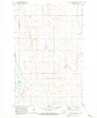
1971 Map of Hurricane Lake West
USGS Topo · Published 1973About this map
Hurricane Lake dominates the eastern boundary of this Pierce County landscape, while the Hurricane Lake National Wildlife Refuge provides a protected habitat along the shoreline. The terrain is defined by a dense network of prairie potholes and wetlands typical of the North Dakota drift plain, with the waters of Rush Lake appearing in the west. This 1971 field-checked survey reveals a quiet agricultural and conservation area where local life centered on landmarks like the Hurricane Lake Ch and a rural Townhall. Small-scale industrial activity is limited to a scattered Gravel Pit, underscoring the era's reliance on local material for maintaining the grid of section roads that partition the section lines of Township 158 North and Township 157 North.
Find a feature on this map
8 named features on this map. Tap any name to fly to it.
Don’t see what you’re looking for? This feature index may not catch every label — zoom into the map to look around manually.
Map Details
Editions of this 1971 Hurricane Lake West Map
This is the sole edition of this map. No revisions or reprints were ever made.
Other maps of this area

1953 · Devils Lake
USGS Topo · 1:250,000

1956 · Devils Lake
USGS Topo · 1:250,000

1971 · Wolford
USGS Topo · 1:24,000

1971 · Bisbee South
USGS Topo · 1:24,000

1971 · Island Lake
USGS Topo · 1:24,000

1971 · Knox
USGS Topo · 1:24,000

1971 · York
USGS Topo · 1:24,000

1971 · Leeds
USGS Topo · 1:24,000

1971 · Mylo SE
USGS Topo · 1:24,000
1971 · Hurricane Lake East
USGS Topo · 1:24,000