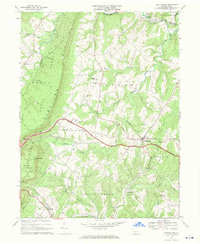
1968 Map of Hustontown
USGS Topo · Published 1970About this map
The ridge-and-valley landscape of Fulton County is dominated by the massive presence of Sideling Hill, which cuts a dramatic diagonal across this late-1960s survey. This mountain corridor, largely preserved within the Wells State Forest, stands in contrast to the agricultural and residential pockets to the east. The Pennsylvania Turnpike carves through this terrain, featuring the prominent Sideling Hill Plaza as a modern landmark of the era's interstate expansion.
Find a feature on this map
39 named features on this map. Tap any name to fly to it.
Don’t see what you’re looking for? This feature index may not catch every label — zoom into the map to look around manually.
Map Details
Editions of this 1968 Hustontown Map
Other maps of this area

1900 · Mercersburg
USGS Topo · 1:62,500

1902 · Mercersburg
USGS Topo · 1:62,500

1925 · Needmore
USGS Topo · 1:48,000

1930 · Broad Top
USGS Topo · 1:62,500

1933 · Broad Top
USGS Topo · 1:62,500

1935 · Needmore
USGS Topo · 1:62,500

1939 · Needmore
USGS Topo · 1:62,500

1939 · Orbisonia
USGS Topo · 1:62,500

1940 · Orbisonia
USGS Topo · 1:62,500

1942 · Hagerstown
USGS Topo · 1:125,000
Featured Places
- Mellotts Mill, Licking Creek Township
- Laidig, Taylor Township
- Saluvia, Licking Creek Township
- Enid, Wells Township
- Licking Creek Township, PA