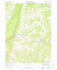
1968 Map of Hustontown
USGS Topo · Published 1974About this map
Hustontown serves as a central hub on this 1968 survey of the Pennsylvania mountains, where the modern path of the Pennsylvania Turnpike cuts across a landscape still defined by 19th-century settlement patterns. The map highlights the intersection of old and new infrastructure, from the Sideling Hill Tunnel and the Sideling Hill Plaza to the historic Mellotts Mill along Mellotts Run. Small communities and crossroad hamlets like Dublin Mills, Saluvia, and Laidig are documented alongside numerous country churches, including Fairview Ch and Wells Valley Ch.
Find a feature on this map
41 named features on this map. Tap any name to fly to it.
Don’t see what you’re looking for? This feature index may not catch every label — zoom into the map to look around manually.
Map Details
Editions of this 1968 Hustontown Map
Other maps of this area

1900 · Mercersburg
USGS Topo · 1:62,500

1902 · Mercersburg
USGS Topo · 1:62,500

1925 · Needmore
USGS Topo · 1:48,000

1930 · Broad Top
USGS Topo · 1:62,500

1933 · Broad Top
USGS Topo · 1:62,500

1935 · Needmore
USGS Topo · 1:62,500

1939 · Needmore
USGS Topo · 1:62,500

1939 · Orbisonia
USGS Topo · 1:62,500

1940 · Orbisonia
USGS Topo · 1:62,500

1942 · Hagerstown
USGS Topo · 1:125,000
Featured Places
- Mellotts Mill, Licking Creek Township
- Laidig, Taylor Township
- Saluvia, Licking Creek Township
- Enid, Wells Township
- Licking Creek Township, PA