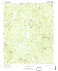
1965 Map of Hutch Mtn.
USGS Topo · Published 1972About this map
Industrial Railroad tracks cut through the high timber of Coconino National Forest in this mid-1960s survey of the Mogollon Rim country. The landscape is defined by its seasonal hydrology and ranching infrastructure, dotted with numerous named tanks like Fulton Canyon Tank and Chilson Tank that support livestock across the high-elevation meadows. Named clearings such as Brolliar Park and Tie Park reveal a history of timber harvesting and grazing. To the east, Hutch Mountain rises as a prominent landmark, equipped with a Lookout and a Radio Facility that underscores the area's role in fire management and communication during the post-war era. Isolated outposts like the K-T Ranch and Coyote Basin Ranch suggest a persistent but sparse human presence, while Allan Lake Landing marks a focal point for water management in this high-altitude terrain.
Find a feature on this map
109 named features on this map. Tap any name to fly to it.
Don’t see what you’re looking for? This feature index may not catch every label — zoom into the map to look around manually.
Map Details
Editions of this 1965 Hutch Mtn. Map
4 editions found
Other maps of this area

1887 · Verde
USGS Topo · 1:250,000

1892 · Verde
USGS Topo · 1:250,000

1923 · Camp Verde
USGS Topo · 1:125,000

1932 · Camp Verde
USGS Topo · 1:125,000

1936 · Camp Verde
USGS Topo · 1:125,000

1954 · Holbrook
USGS Topo · 1:250,000

1957 · Holbrook
USGS Topo · 1:250,000

1958 · Holbrook
USGS Topo · 1:250,000

1960 · Holbrook
USGS Topo · 1:250,000
1965 · Hutch Mtn.
USGS Topo · 1:24,000