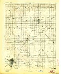
1893 Map of Hutchinson
USGS Topo · Published 1905About this map
McPherson and Hutchinson anchor this late nineteenth-century survey of the central Kansas prairie, where the expanding rail network dictated the growth of local commerce. The landscape is defined by the heavy presence of the Atchison Topeka and Santa Fe Railroad and the Chicago Kansas and Nebraska Railway, which intersect at several key junctions. This era shows the transition from isolated rural townships like Little Valley and King City to established market centers. Water sources were critical for both agriculture and steam power, as seen in the prominent drainage of the Arkansas River and unique prairie features like Lake Inman and Lake Farland. The map preserves the original township divisions, such as New Gottland and Superior, providing a clear view of the settlement patterns that emerged as the railroads opened the region to wider trade.
Find a feature on this map
72 named features on this map. Tap any name to fly to it.
Don’t see what you’re looking for? This feature index may not catch every label — zoom into the map to look around manually.
Map Details
Editions of this 1893 Hutchinson Map
5 editions found
Other maps of this area

1889 · Newton
USGS Topo · 1:125,000

1889 · Abilene
USGS Topo · 1:125,000

1889 · Cheney
USGS Topo · 1:125,000

1889 · Wichita
USGS Topo · 1:125,000

1891 · Hutchinson
USGS Topo · 1:125,000

1891 · Cheney
USGS Topo · 1:125,000

1892 · Salina
USGS Topo · 1:125,000

1892 · Kingman
USGS Topo · 1:125,000

1893 · Hutchinson
USGS Topo · 1:125,000

1894 · Ellsworth
USGS Topo · 1:125,000