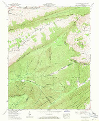
1958 Map of Hutchinson Rock
USGS Topo · Published 1971About this map
The Jefferson National Forest dominates this mid-century survey, revealing a landscape defined by the convergence of the Tazewell and Bland and Smyth and Tazewell county lines. The high ridgelines of Rich Mountain and Clinch Mountain create a series of isolated valleys where early settlement patterns remain visible. Along the upper reaches of the South Fork Clinch River and Maiden Spring Creek, local genealogy is well-preserved through family-named landmarks such as Buchanan Cem and Thompson Cem.
Find a feature on this map
62 named features on this map. Tap any name to fly to it.
Don’t see what you’re looking for? This feature index may not catch every label — zoom into the map to look around manually.
Map Details
Editions of this 1958 Hutchinson Rock Map
3 editions found
Other maps of this area

1887 · Pocahontas
USGS Topo · 1:125,000

1889 · Wytheville
USGS Topo · 1:125,000

1891 · Tazewell
USGS Topo · 1:125,000

1891 · Pocahontas
USGS Topo · 1:125,000

1891 · Abingdon
USGS Topo · 1:125,000

1892 · Wytheville
USGS Topo · 1:125,000

1894 · Pocahontas
USGS Topo · 1:125,000

1894 · Abingdon
USGS Topo · 1:125,000

1895 · Tazewell
USGS Topo · 1:125,000

1895 · Pocahontas
USGS Topo · 1:125,000