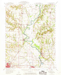
1957 Map of Hutsonville
USGS Topo · Published 1969About this map
The Wabash River meanders along the Illinois-Indiana border in this late-1950s survey, defining a landscape shaped by river commerce and rail transportation. On the Indiana side, the Merom Institute sits atop a bluff overlooking the Merom Ferry, while the Illinois shoreline features the prominent Hutsonville Cutoff and the industrial infrastructure of an Oil Refinery near Gordon. The presence of several Indian Mounds near the river suggests a deep history of settlement, predating the modern grid of schools and churches like Ohio Chapel and Kingsley Ch.
Find a feature on this map
78 named features on this map. Tap any name to fly to it.
Don’t see what you’re looking for? This feature index may not catch every label — zoom into the map to look around manually.
Map Details
Editions of this 1957 Hutsonville Map
2 editions found

Other maps of this area

1910 · Hardinville
USGS Topo · 1:62,500

1917 · Birds
USGS Topo · 1:62,500

1932 · Marshall
USGS Topo · 1:62,500

1936 · Casey
USGS Topo · 1:48,000

1937 · Marshall
USGS Topo · 1:62,500

1940 · Pimento
USGS Topo · 1:24,000

1942 · Fairbanks
USGS Topo · 1:24,000

1942 · Shelburn
USGS Topo · 1:24,000

1942 · Hutton
USGS Topo · 1:24,000

1942 · Birds
USGS Topo · 1:62,500