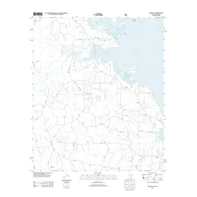
2012 Map of Huxley
USGS Topo · Published 2012About this map
Toledo Bend Reservoir dominates the northeastern landscape of this Shelby County region, where the Sabine River drainage defines the border between Texas and Louisiana. The settlement of Huxley sits near the southern edge, connected by a network of farm-to-market roads like FM 2694 and FM 139. This survey documents a transition from the dense woodlands of National Forest Spring to the irregular shoreline and inlets of Wildcat Bend. Local history is deeply etched into the land through numerous family and community burial grounds, including Ashton Cem, Carroll Cem, and Wimberly Cem. Inland, the Tenaha Lookout Tower stands as a prominent landmark near Mason Lake and Goodsons Lake, overlooking the complex creek systems of Grannies Cr and Tenaha Bayou. Small crossroads communities like Vaughan and Boles Field represent the scattered rural development typical of the East Texas Piney Woods during this era.
Find a feature on this map
52 named features on this map. Tap any name to fly to it.
Don’t see what you’re looking for? This feature index may not catch every label — zoom into the map to look around manually.
Map Details
Editions of this 2012 Huxley Map
This is the sole edition of this map. No revisions or reprints were ever made.
Other maps of this area

1944 · Logansport
USGS Topo · 1:62,500

1944 · Patroon
USGS Topo · 1:62,500

1953 · Alexandria
USGS Topo · 1:250,000

1953 · Palestine
USGS Topo · 1:250,000

1955 · Alexandria
USGS Topo · 1:250,000

1956 · Logansport
USGS Topo · 1:62,500

1956 · Patroon
USGS Topo · 1:62,500

1957 · Palestine
USGS Topo · 1:250,000

1958 · Center
USGS Topo · 1:62,500

1958 · San Augustine
USGS Topo · 1:62,500