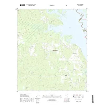
2019 Map of Huxley
USGS Topo · Published 2019About this map
Huxley anchors this East Texas landscape along the western shore of the Toledo Bend Reservoir, where the state line with Louisiana follows the submerged channel of the Sabine River. Much of the terrain is defined by the Sabine National Forest, characterized by numerous creek drainages such as Tenaha Bayou, Grannies Cr, and Brawley Cr. The map preserves several local burial sites vital for genealogical research, including Strong Cem, Wimberly Cem, and Holly Springs Cem. Near the northern reaches of the reservoir, features like Wildcat Bend and Horseshoe Lake indicate the complex hydrology of the area, while smaller interior water bodies like Goodsons Lake and Mason Lake are found deeper within the timbered reaches. A network of country roads and forestry routes provides access through the piney woods and along the irregular shoreline.
Find a feature on this map
50 named features on this map. Tap any name to fly to it.
Don’t see what you’re looking for? This feature index may not catch every label — zoom into the map to look around manually.
Map Details
Editions of this 2019 Huxley Map
This is the sole edition of this map. No revisions or reprints were ever made.
Other maps of this area

1944 · Logansport
USGS Topo · 1:62,500

1944 · Patroon
USGS Topo · 1:62,500

1953 · Alexandria
USGS Topo · 1:250,000

1953 · Palestine
USGS Topo · 1:250,000

1955 · Alexandria
USGS Topo · 1:250,000

1956 · Logansport
USGS Topo · 1:62,500

1956 · Patroon
USGS Topo · 1:62,500

1957 · Palestine
USGS Topo · 1:250,000

1958 · Center
USGS Topo · 1:62,500

1958 · San Augustine
USGS Topo · 1:62,500