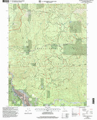
1998 Map of Hyampom Mountain
USGS Topo · Published 2003About this map
The convergence of the Trinity River and Hayfork Creek dominates this mountainous landscape in Northern California. In the late 1990s, this area reflects a junction of forest management and industrial legacy within the Shasta-Trinity National Forest and Six Rivers National Forest. Small-scale infrastructure like the Hyampom Airport and a nearby Sawmill provide evidence of local utility and timber history, while named homesteads such as Skunk Ranch and Wigdon Place offer clues for genealogists tracking rural habitation in Trinity County.
Find a feature on this map
40 named features on this map. Tap any name to fly to it.
Don’t see what you’re looking for? This feature index may not catch every label — zoom into the map to look around manually.
Map Details
Editions of this 1998 Hyampom Mountain Map
This is the sole edition of this map. No revisions or reprints were ever made.
Other maps of this area

1909 · Big Bar
USGS Topo · 1:96,000

1914 · Pilot Creek
USGS Topo · 1:62,500

1915 · Big Bar and Vicinity
USGS Topo · 1:250,000

1922 · China Flat
USGS Topo · 1:62,500

1951 · Pilot Creek
USGS Topo · 1:62,500

1951 · Hyampom
USGS Topo · 1:62,500

1951 · Ironside Mountain
USGS Topo · 1:62,500

1952 · Willow Creek
USGS Topo · 1:62,500

1958 · Redding
USGS Topo · 1:250,000
1978 · Blake Mountain
USGS Topo · 1:24,000