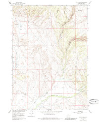
1960 Map of Hyatt Ranch
USGS Topo · Published 1985About this map
Hyatt Ranch and other established homesteads like Taylor Ranch and Greer Ranch anchor this 1960 survey of the Big Horn Basin. The landscape is defined by the drainage of Paint Rock Creek and Medicine Lodge Creek, where water rights and irrigation are evident through a network of ditches and gaging stations. Evidence of early communal life can be found at the Pritchards Grove Picnic Area and the Hyattville Cem located near the southern margin.
Find a feature on this map
27 named features on this map. Tap any name to fly to it.
Don’t see what you’re looking for? This feature index may not catch every label — zoom into the map to look around manually.
Map Details
Editions of this 1960 Hyatt Ranch Map
4 editions found
Other maps of this area

1899 · Cloud peak
USGS Topo · 1:125,000

1901 · Cloud Peak
USGS Topo · 1:125,000

1955 · Sheridan
USGS Topo · 1:250,000

1958 · Sheridan
USGS Topo · 1:250,000

1960 · White Sulphur Spring
USGS Topo · 1:24,000

1960 · Flitner Reservoir
USGS Topo · 1:24,000

1960 · Spanish Point
USGS Topo · 1:24,000

1960 · Hyatt Ranch
USGS Topo · 1:24,000
1960 · Bush Butte
USGS Topo · 1:24,000

1962 · Sheridan
USGS Topo · 1:250,000