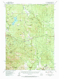
1955 Map of Hyatt Reservoir
USGS Topo · Published 1963About this map
The high timber and ranch lands of southern Oregon are captured here in the mid-1950s, centered on the expansion of Hyatt Reservoir and the Siskiyou Mountains. This era shows a working mountain landscape where the Green Springs Highway serves as the primary artery connecting remote holdings like Summit Ranch and Schoolhouse Ranch. The settlement of Lincoln is particularly detailed, showing a local economy tied to the land with its Millpond and nearby Mt View Airport. The map documents the intricate water system of the Rogue River watershed, tracing Keene Creek and the smaller Little Hyatt Reservoir against the high peaks of Soda Mtn and Chinquapin Mtn. This topographic record also preserves the locations of numerous historic high-country ranching operations, including the Box D Ranch and Open Triangle Tee Ranch near the California border.
Find a feature on this map
88 named features on this map. Tap any name to fly to it.
Don’t see what you’re looking for? This feature index may not catch every label — zoom into the map to look around manually.
Map Details
Editions of this 1955 Hyatt Reservoir Map
3 editions found

Other maps of this area

1886 · Shasta
USGS Topo · 1:250,000

1891 · Ashland
USGS Topo · 1:250,000

1893 · Ashland
USGS Topo · 1:250,000

1894 · Shasta
USGS Topo · 1:250,000

1897 · Ashland
USGS Topo · 1:250,000

1922 · Shasta Valley Sheet No 16
USGS Topo · 1:24,000

1922 · Shasta Valley Sheet No 15
USGS Topo · 1:24,000

1932 · Yreka
USGS Topo · 1:96,000

1934 · Macdoel
USGS Topo · 1:96,000

1938 · Medford
USGS Topo · 1:125,000