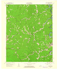
1961 Map of Hyden West
USGS Topo · Published 1962About this map
The Middle Fork Kentucky River snakes through the eastern portion of this Leslie County landscape, anchoring the community of Hyden and the neighboring settlement of Dryhill. In the early 1960s, this region was characterized by the intersection of traditional Appalachian hollow life and emerging industrial footprints. Evidence of extraction is clear at the Strip Mine near Sizerock and various Gas Well sites scattered throughout the hills.
Find a feature on this map
78 named features on this map. Tap any name to fly to it.
Don’t see what you’re looking for? This feature index may not catch every label — zoom into the map to look around manually.
Map Details
Editions of this 1961 Hyden West Map
2 editions found
Other maps of this area

1891 · Manchester
USGS Topo · 1:125,000

1891 · Hazard
USGS Topo · 1:125,000

1913 · Buckhorn
USGS Topo · 1:62,500

1916 · Hyden
USGS Topo · 1:48,000

1919 · Hyden
USGS Topo · 1:62,500

1953 · Buckhorn
USGS Topo · 1:24,000

1953 · Hyden West
USGS Topo · 1:24,000

1953 · Big Creek
USGS Topo · 1:24,000

1953 · Mistletoe
USGS Topo · 1:24,000

1954 · Krypton
USGS Topo · 1:24,000