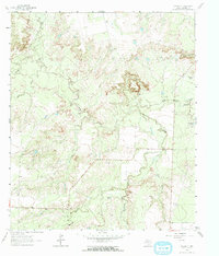
1962 Map of Hyman NE
USGS Topo · Published 1964About this map
The rugged drainage systems of Beals Creek and its many tributaries define this 1962 landscape in Mitchell County. This arid terrain is marked by essential water management features, including the Whitten Dam and various stock tanks such as Meteor Tank, Vowell Tank, and Calf Creek Tank. The mapping of these features, alongside many unnamed windmills and a Gaging Sta, reflects the vital importance of water infrastructure for ranching in the Texas ranch country during the early 1960s.
Find a feature on this map
15 named features on this map. Tap any name to fly to it.
Don’t see what you’re looking for? This feature index may not catch every label — zoom into the map to look around manually.
Map Details
Editions of this 1962 Hyman NE Map
2 editions found
Other maps of this area

1950 · Lake Colorado City
USGS Topo · 1:24,000

1951 · Iatan
USGS Topo · 1:24,000

1952 · Iatan
USGS Topo · 1:24,000

1952 · Westbrook
USGS Topo · 1:24,000

1954 · Big Spring
USGS Topo · 1:250,000

1958 · Big Spring
USGS Topo · 1:250,000

1959 · Spade Ranch
USGS Topo · 1:24,000

1959 · McWhorter Mountain
USGS Topo · 1:24,000

1962 · Hyman NE
USGS Topo · 1:24,000

1963 · Buffalo Draw
USGS Topo · 1:24,000