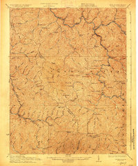
1927 Map of Iaeger
USGS Topo · Published 1927About this map
The Norfolk and Western RR winds along the Tug Fork river valley, anchoring the industrial and social life of this coal-country landscape. This 1927 edition, based on earlier surveys by R.B. Marshall and Frank Sutton, reveals a high density of rural schoolhouses and family-named landmarks scattered across the complex terrain of the Sandy River district. Small post office settlements like Avondale PO Ritter and Gluck Lex PO serve as vital nodes for remote mountain communities.
Find a feature on this map
84 named features on this map. Tap any name to fly to it.
Don’t see what you’re looking for? This feature index may not catch every label — zoom into the map to look around manually.
Map Details
Editions of this 1927 Iaeger Map
3 editions found
Other maps of this area

1886 · Grundy
USGS Topo · 1:125,000

1887 · Warfield
USGS Topo · 1:125,000

1890 · Grundy
USGS Topo · 1:125,000

1891 · Tazewell
USGS Topo · 1:125,000

1891 · Oceana
USGS Topo · 1:125,000

1891 · Warfield
USGS Topo · 1:125,000

1892 · Grundy
USGS Topo · 1:125,000

1893 · Oceana
USGS Topo · 1:125,000

1895 · Tazewell
USGS Topo · 1:125,000

1897 · Tazewell
USGS Topo · 1:125,000