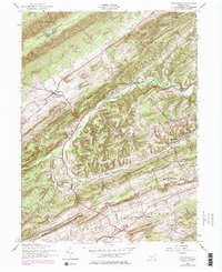
1952 Map of Ickesburg
USGS Topo · Published 1978About this map
Ickesburg and its surrounding hamlets are defined by a rhythmic sequence of ridges and valleys typical of Perry County. This 1952 record highlights a landscape shaped by agricultural tradition and the persistent geography of the Tuscarora Mountain region. The settlement pattern follows the fertile valleys between Sherman Ridge and Limestone Ridge, where community life centered on sites like Ickesburg High School, Wesley Chapel, and the Mannsville School.
Find a feature on this map
48 named features on this map. Tap any name to fly to it.
Don’t see what you’re looking for? This feature index may not catch every label — zoom into the map to look around manually.
Map Details
Editions of this 1952 Ickesburg Map
4 editions found
Other maps of this area

1907 · New Bloomfield
USGS Topo · 1:62,500

1907 · Millerstown
USGS Topo · 1:62,500

1925 · Mifflintown
USGS Topo · 1:48,000

1930 · Loysville
USGS Topo · 1:62,500

1933 · Loysville
USGS Topo · 1:62,500

1934 · Mifflintown
USGS Topo · 1:62,500

1937 · Mifflintown
USGS Topo · 1:62,500

1943 · Millerstown
USGS Topo · 1:62,500

1943 · New Bloomfield
USGS Topo · 1:62,500

1950 · Harrisburg
USGS Topo · 1:250,000
Featured Places
- Saville Township, PA
- Centre Township, PA
- Tuscarora Township, PA
- Little Germany, Spring Township
- Eshcol, Saville Township