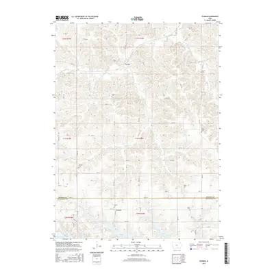
2015 Map of Iconium
USGS Topo · Published 2015About this map
The boundary between Monroe and Appanoose Counties divides this southern Iowa landscape, where small rural communities are defined by their proximity to the water. The unincorporated settlement of Iconium sits south of the county line, accompanied by the Iconium Cemetery, while the hamlet of Tyrone is located to the north along the upper reaches of Mormon Br. This territory is characterized by a high density of family and community burial grounds, including Salem, Welch, and Mount Carmel, which provide significant points of interest for genealogical research in the Chariton River valley area. The southern edge of the map is dominated by the northern fingers of Rathbun Lake, where the landscape transitions from agricultural creek bottoms to the managed waters of the reservoir. Numerous named tributaries such as Moffatt Br, Honey Cr, and Contrary Cr carve through the terrain, illustrating the complex drainage system that feeds the larger basin.
Find a feature on this map
65 named features on this map. Tap any name to fly to it.
Don’t see what you’re looking for? This feature index may not catch every label — zoom into the map to look around manually.
Map Details
Editions of this 2015 Iconium Map
This is the sole edition of this map. No revisions or reprints were ever made.
Other maps of this area
1924 · Melcher
USGS Topo · 1:62,500
1929 · Albia
USGS Topo · 1:62,500
1935 · Russell
USGS Topo · 1:62,500
1938 · Russell
USGS Topo · 1:62,500
1939 · Mystic
USGS Topo · 1:62,500
1942 · Mystic
USGS Topo · 1:62,500

1954 · Centerville
USGS Topo · 1:250,000
1954 · Des Moines
USGS Topo · 1:250,000
1956 · Des Moines
USGS Topo · 1:250,000
1957 · Des Moines
USGS Topo · 1:250,000