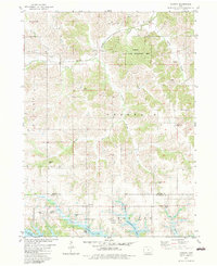
1982 Map of Iconium
USGS Topo · Published 1983About this map
The settlement of Iconium and the surrounding borderlands of Monroe and Appanoose Counties are captured here following a period of significant hydrological change. The southern edge of the map is dominated by the waters of Rathbun Lake, a reservoir that reshaped the landscape around Honey Creek and Ham Branch Cr. This transition from river valley to recreation area is highlighted by the Rathbun State Resort Area and local infrastructure like a Trailer Park and Sewage Disposal Pond.
Find a feature on this map
33 named features on this map. Tap any name to fly to it.
Don’t see what you’re looking for? This feature index may not catch every label — zoom into the map to look around manually.
Map Details
Editions of this 1982 Iconium Map
This is the sole edition of this map. No revisions or reprints were ever made.
Other maps of this area

1924 · Melcher
USGS Topo · 1:62,500

1929 · Albia
USGS Topo · 1:62,500

1935 · Russell
USGS Topo · 1:62,500

1938 · Russell
USGS Topo · 1:62,500

1939 · Mystic
USGS Topo · 1:62,500

1942 · Mystic
USGS Topo · 1:62,500

1954 · Centerville
USGS Topo · 1:250,000

1954 · Des Moines
USGS Topo · 1:250,000

1956 · Des Moines
USGS Topo · 1:250,000

1957 · Des Moines
USGS Topo · 1:250,000