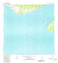
1959 Map of Icy Bay D-2 and D-3
USGS Topo · Published 1983About this map
The remote glacial shoreline of the Gulf of Alaska is meticulously charted in this late 1950s survey of the Yakutat region. The map captures the complex interaction of land and water around Icy Bay, where features like Point Riou Spit and Tsimpshian Point define the protected waters of Riou Bay. On the eastern shore, Sacred Lake sits just inland from the mouth of the Yahtse River, providing a rare inland water body amidst the shifting sands and moraines.
Find a feature on this map
25 named features on this map. Tap any name to fly to it.
Don’t see what you’re looking for? This feature index may not catch every label — zoom into the map to look around manually.
Map Details
Editions of this 1959 Icy Bay D-2 and D-3 Map
3 editions found
Other maps of this area

1948 · Icy Bay D-2 and D-3
USGS Topo · 1:63,360

1950 · Bering Glacier A-3
USGS Topo · 1:63,360

1950 · Bering Glacier
USGS Topo · 1:250,000

1950 · Icy Bay
USGS Topo · 1:250,000

1951 · Icy Bay D-2 and D-3
USGS Topo · 1:63,360

1951 · Icy Bay
USGS Topo · 1:250,000

1951 · Bering Glacier
USGS Topo · 1:250,000

1951 · Bering Glacier A-2
USGS Topo · 1:63,360
1959 · Icy Bay D-2 and D-3
USGS Topo · 1:63,360

1959 · Bering Glacier
USGS Topo · 1:250,000