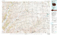
1985 Map of Ida Grove
USGS Topo · Published 1993About this map
Ida Grove serves as a central hub in this Western Iowa landscape, where the agricultural grid is defined by a network of river valleys and historical rail corridors. The Maple River and Boyer River valleys dictate the placement of numerous established settlements, including Denison, Mapleton, and Odebolt. The transportation infrastructure is dominated by the tracks of the Chicago and North Western and Illinois Central Gulf railroads, which facilitated the growth of these grain-handling communities.
Find a feature on this map
60 named features on this map. Tap any name to fly to it.
Don’t see what you’re looking for? This feature index may not catch every label — zoom into the map to look around manually.
Map Details
Editions of this 1985 Ida Grove Map
2 editions found
Other maps of this area

1954 · Omaha
USGS Topo · 1:250,000

1954 · Fort Dodge
USGS Topo · 1:250,000

1955 · Sioux City
USGS Topo · 1:250,000

1955 · Fremont
USGS Topo · 1:250,000

1957 · Fremont
USGS Topo · 1:250,000

1957 · Omaha
USGS Topo · 1:250,000

1957 · Fort Dodge
USGS Topo · 1:250,000

1958 · Sioux City
USGS Topo · 1:250,000

1958 · Omaha
USGS Topo · 1:250,000

1958 · Fremont
USGS Topo · 1:250,000