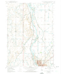
1948 Map of Idaho Falls North
USGS Topo · Published 1975About this map
The Snake River dominates this northern periphery of the county seat, where a sophisticated network of irrigation canals supported mid-century agriculture. Water from the river is diverted into an intricate system of laterals and ditches, including the Osgood Canal, Great Western Canal, and Sage Canal, illustrating the engineering required to sustain the upper Snake River Plain. Rural life is anchored by local institutions like the Coltman Ward Church, Fairview School, and St Leon Grange, marking the social centers of these small farming communities.
Find a feature on this map
61 named features on this map. Tap any name to fly to it.
Don’t see what you’re looking for? This feature index may not catch every label — zoom into the map to look around manually.
Map Details
Editions of this 1948 Idaho Falls North Map
4 editions found
Other maps of this area

1924 · Ammon
USGS Topo · 1:62,500

1948 · Woodville
USGS Topo · 1:24,000

1948 · Rigby
USGS Topo · 1:24,000

1948 · Lewisville
USGS Topo · 1:24,000

1948 · Idaho Falls North
USGS Topo · 1:24,000

1948 · Idaho Falls South
USGS Topo · 1:24,000

1948 · Ucon
USGS Topo · 1:24,000

1949 · Ucon
USGS Topo · 1:24,000

1949 · Idaho Falls North
USGS Topo · 1:24,000

1949 · Rigby
USGS Topo · 1:24,000