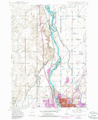
1948 Map of Idaho Falls North
USGS Topo · Published 1986About this map
The Snake River carves a central path through this Idaho landscape, where a sophisticated network of irrigation sustains the high desert agriculture of the late 1940s. A dense web of waterways, including the Great Western Canal, Osgood Canal, and Idaho Canal, underscores the engineering required to support settlements like Coltman and Osgood. The industrial and civic footprint of Idaho Falls is evident at the southern edge, featuring the Idaho Falls Municipal Power Plant and the Idaho Falls Municipal Airport.
Find a feature on this map
46 named features on this map. Tap any name to fly to it.
Don’t see what you’re looking for? This feature index may not catch every label — zoom into the map to look around manually.
Map Details
Editions of this 1948 Idaho Falls North Map
4 editions found
Other maps of this area

1924 · Ammon
USGS Topo · 1:62,500

1948 · Woodville
USGS Topo · 1:24,000

1948 · Rigby
USGS Topo · 1:24,000

1948 · Lewisville
USGS Topo · 1:24,000

1948 · Idaho Falls North
USGS Topo · 1:24,000

1948 · Idaho Falls South
USGS Topo · 1:24,000

1948 · Ucon
USGS Topo · 1:24,000

1949 · Ucon
USGS Topo · 1:24,000

1949 · Idaho Falls North
USGS Topo · 1:24,000

1949 · Rigby
USGS Topo · 1:24,000